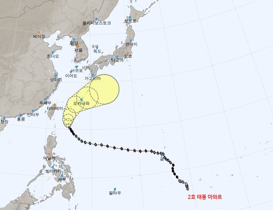
The second typhoon ‘MAWAR’, which hit all over Guam, turned from the sea east of Taiwan to the Japanese mainland and started heading north.
According to the Korea Meteorological Administration on the 30th, as of 9 am on the same day, Mawar is passing through the sea about 630 km southeast of Taipei, Taiwan at a speed of 10 km per hour.
The central air pressure of Mawar is 955 hPa (hectopascal), and the maximum wind speed is 144 km/h. However, this wind speed is also a force that can derail a running train.
Mawar entered the Sakishima Islands on the 31st and is likely to approach the main island of Okinawa over the weekend, the 3rd of next month. As a result, rain damage is expected to occur in western Japan as well.
 Projected path of Typhoon No. 2 ‘MAWAR’. Provided by the Korea Meteorological Administration
Mawar is expected to be affected for a long time at a relatively slow pace, so it is necessary to be vigilant for storms, tidal waves and heavy rain.
Japan’s meteorological authorities issued a heavy rain warning mainly in western Japan on the 30th due to power lines and humid air due to the influence of Mawar, and asked for attention to landslides. From the 31st, storms, tsunamis and heavy rain are expected in the area around Okinawa.
Unless there are other variables, it is highly likely that Mawar will travel along the front of Honshu, the Japanese mainland. It is predicted to move northeast from the dawn of the 2nd of next month and pass the sea around 560 km northeast of Okinawa, Japan around 9:00 am on the 4th. At this time, Mawar is expected to move from the southern part of Shikoku Island, Japan.
Korea is unlikely to be directly affected by Mawar. However, water vapor moves along with the northward of Mawar, and the possibility of precipitation in the southern coast and Jeju after the 3rd of next month may increase.
Source: Donga
Mark Jones is a world traveler and journalist for News Rebeat. With a curious mind and a love of adventure, Mark brings a unique perspective to the latest global events and provides in-depth and thought-provoking coverage of the world at large.